When I was a kid starting to get curious about local history, the story I heard about West Covina's Glendora Avenue was that it was called that because in olden days it went to Glendora. It did seem to point in that general direction, so I always assumed the tale was true.
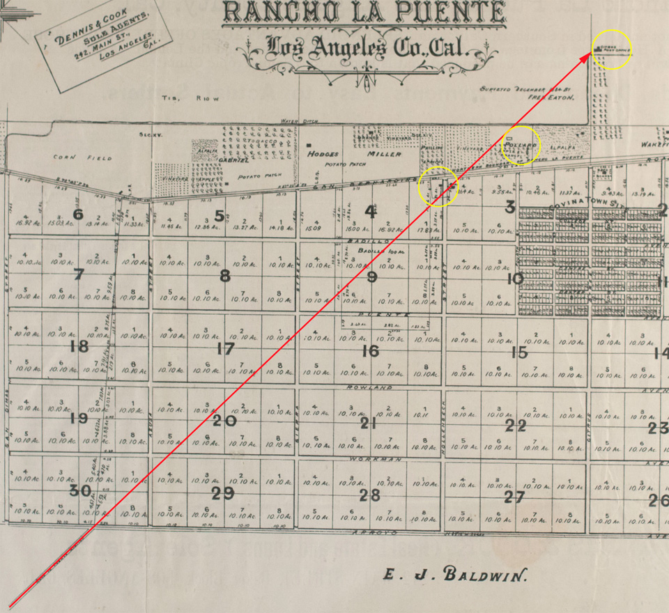
But where did Glendora Avenue actually go in historical times? I didn't think to figure that out until just the other day. Turns out if I take the original 1885 survey map of Covina and precisely extend the line of today's Glendora Avenue, it very conveniently connects three important historical sites: the Julián Badilla home (1876), Eugene Griswold's 1877 Citrus Post Office and general store, and the homestead of Robert J. Pollard, who I have recently come to believe may have been the Covina area's first settler of European descent.

Detail of Phillips Tract map (1885) showing a proposed historical northward extension of Glendora Avenue/Puente Depot Road (red arrow).
Yellow circles indicate the Badilla, Pollard and Griswold properties respectively. Map courtesy Covina Valley Historical Society.
No maps from the 1870s show that such a road existed through the future Covina area, but it would make sense that one did, because if you were Mr. Pollard or Mr. Griswold or the Sres. Badilla, you would need a wagon road in that exact location and orientation to get you to Puente, which was not only the headquarters town of Rancho La Puente, it was also the location of the then-new Southern Pacific Railroad depot, which at the time would have been your main transportation link to the greater world beyond.
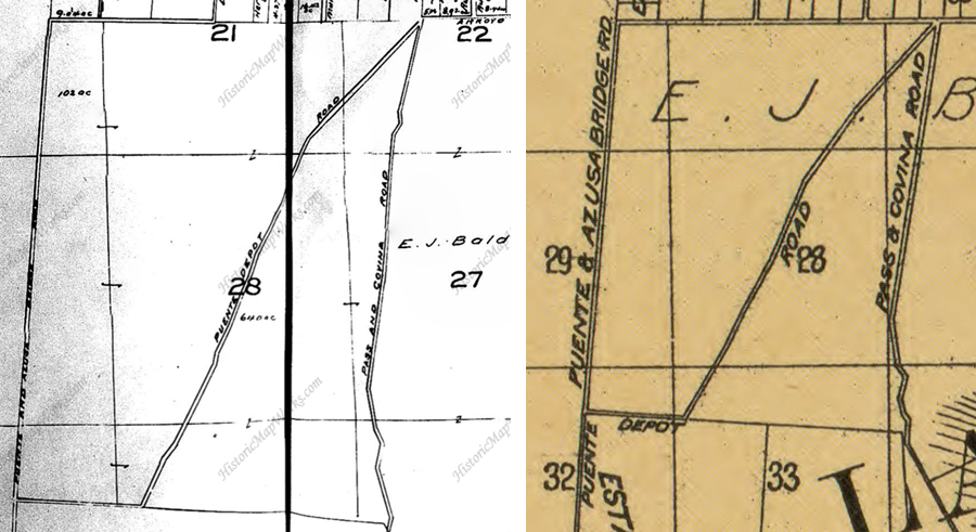
But there are maps from turn of the 20th century that do show a "Puente Depot Road" roughly tracing the path of today's Glendora Avenue. To realize my scenario, we need only imagine that the depot road went further north before the grid of streets for Covina was laid out in 1883-1884.

Maps from c.1900 showing "Puente Depot Road." Courtesy HistoricMapWorks.com and Library of Congress.
I don't think the diagonal Glendora Avenue we know today necessarily followed that same alignment all the way north, though. All it had to do was go as far as Citrus Avenue–a main thoroughfare even in the 1870s–and from there, you could have taken it up to Azusa or the foothills, where it ended at Fairmount Cemetery. In any case, Glendora wasn't founded until 1886, so the road we now call Glendora Avenue never went to such a place to begin with. The story behind the name turns out to be only the stuff of legend, after all.
One more thing: let's say the depot road did extend north to Citrus Avenue, that would finally answer a nagging question I've had for a long time, which was, why did the Badillas choose to build their HQ exactly where they did? That particular spot always seemed less than ideal to me. However, if we assume that in 1876, it was the intersection of the most crucial local roads at the time: San Bernardino Road (the most direct route to Los Angeles), the Puente Depot Road, and from there, the road north to Azusa, then the Badillas' chosen location makes perfect logistical sense.
This makes me think that the depot road existed before the Badillas arrived. So who first blazed the old wagon track to Puente? No way of knowing for certain at this point, but my guess would be R. J. Pollard, who may have been there before anybody else, but that I have yet to establish.
Much speculation here, I acknowledge, but a lot of history is informed speculation based on previously-known facts. And it's fun stuff to think about, anyway! I mean a historian's gotta have fun once in a while, right? Right!
Grateful thanks to Michael Schoenholtz and Randall Smith for research and discussion.
No comments:
Post a Comment
To post a comment, you must login to this page with the Google Chrome web browser. That is the only way that works now.