Looking back, I realize that Covina Hills Road was the likely origin of my fascination with olden times. We moved to the Ranchos when I was 5, and even at that young age, I noticed that, taking Rowland towards home, the instant we passed Grand onto Covina Hills Road, the scene changed from modern suburbia to cowboy days. Along almost its whole length were sights to behold that looked frankly ancient to me. Maybe this had been a stagecoach road, or an old indian trail, but no matter who I asked or what library books I read, no one could ever tell me anything about Covina Hills Road that came even close to answering all the questions I had about it. A lifetime would pass before I was able to discover the road's forgotten story myself...
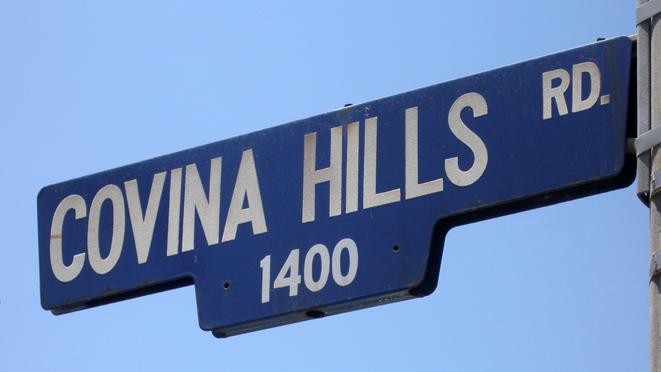
Corner of CHR and Via Verde, San Dimas, June 26, 2010. Photo © J Scott Shannon.

Known by a variety of names over the years, today's Covina Hills Road began its existence in early 1895 as a mile-long access road to the headquarter buildings of the McCarthy Company's Hollenbeck Ranch partition southeast of town.1

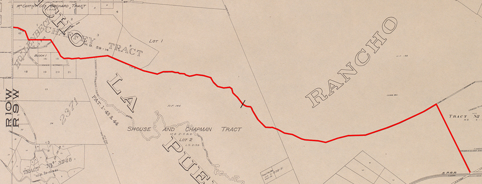
Survey map from August, 1895,1 showing the new Hollenbeck Ranch road (yellow) as an extension of Rowland Avenue in the Phillips Tract.
Courtesy Los Angeles Dept. of Public Works.
The year previous, however, a committee of the Pomona Board of Trade together with officials and supervisors of Los Angeles County had already recommended creation of a road extending all the way over the San Jose Hills to give Pomona a more direct route to the San Gabriel Valley and points west.2 At the time, travelers from Pomona wanting to go to Covina had to divert around the hills: either north via Lordsburg (La Verne) and San Dimas, or west via the Old Spanish Trail (today's Valley Blvd.) then north on Pass and Covina Road. If they could cross directly over the hills, though, it would take at least five miles off the trip,3 which in the days before automobiles could mean an hour of time saved.
The route as surveyed in the summer of 1895 passed through the Phillips Ranch4 on the east over what we now call Kellogg Hill, then through Hollenbeck Ranch lands on the Covina side.3 After the rights-of-way were obtained and obstacles to construction overcome, work on the Pomona County Road was completed in four months in early 1896 for a total cost of $1,100.5
The original as-built alignment of the Pomona Road (red). Since 1933, the road has ended at the point indicated by the black slash.
There were problems from the start, however. A letter to the editor of the Los Angeles Herald printed only weeks after completion complained that the road was little more than a trail "...that would have been hard for a rabbit to go over."5 While the narrowness at the summit was soon dealt with, a more persistent problem was that the adobe dirt roadbed turned into a muddy mire after rains.6 Although still passable for much of the year, the Pomona & Covina Road increasingly came to be regarded as more trouble than it was worth.7
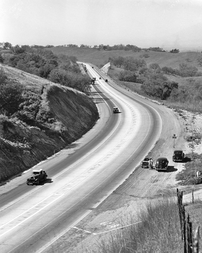
Looking up the hill on the Pomona side, 1908. Today, this is Interstate 10.
Then, in 1923, after years of relative disuse, a petition for abandonment was submitted to the Board of Supervisors. Protests and a counter-proposal soon followed. Cities on both sides urged that not only should the County not close the road, it should be rehabilitated.6 The Board agreed, and work on an improved and widened Pomona & Covina Road was completed in January, 1925.7
Concurrently, however, commercial interests in San Bernardino County were actively pushing a bigger and better idea—the creation of the Arrow Highway—a straight-line interurban boulevard connecting San Bernardino and Los Angeles that would completely bypass the San Jose Hills.8 Rights-of-way in the eastern county were quickly secured, but disputes over routing through La Verne and Covina stalemated completion.9,10 When it became clear the Arrow Highway was not going to be the easy solution it first seemed, the existing road over the hills from Pomona once again became a focus of planners.
In August, 1927, the County decided to further streamline the route west from Pomona and bypass Covina.11 This cutoff, which opened in May, 1928,12 is the present-day Holt Avenue in West Covina.
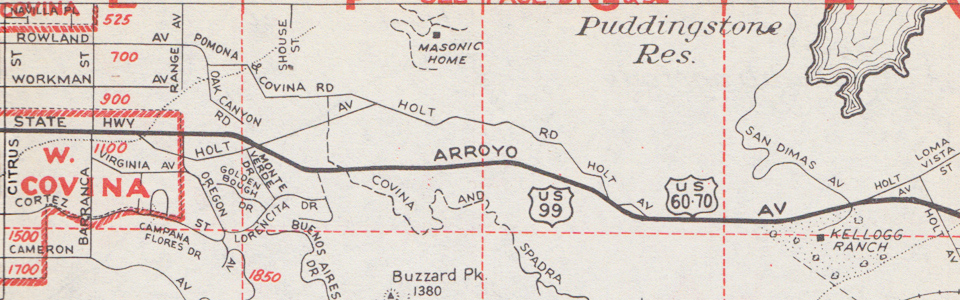
The older roads to and from Pomona were named Holt from 1928 to 1947. Detail from The New Renie Atlas, Los Angeles County, Victory Edition, May, 1943.
For the next few years, the now renamed Holt Road over the hills was the busiest it ever was or would be, and the most dangerous. Many problems were apparent. A single lane in either direction was obviously inadequate, the many blind curves made the safety situation even worse, and the hillside through the canyon section was too steep to allow for further widening. This road could never be engineered to serve as a major artery.
So, in 1931, the State Highway Commission approved plans for an entirely different alignment to run as straight as possible over the San Jose Hills to the San Gabriel Valley. The new Holt-Garvey Highway (State Highway 26, County Route 7)13 was completed between Pomona and Covina in May, 1933.14 From that point until after the war, the obsolete older road became a mostly neglected byway.
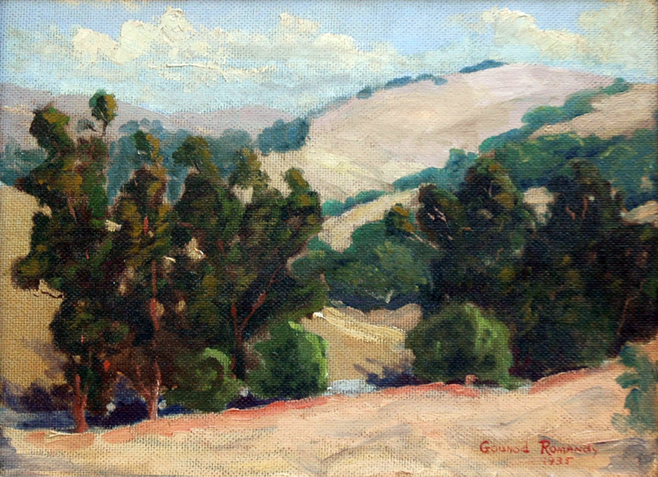
"Hills of Covina, California" by Gounod Romandy (1935): a peaceful country scene painted after the old road to Covina (foreground) had been bypassed.
The street names "Pomona & Covina Road" and "Holt Road" were officially retired in April, 1947, when the Los Angeles County Board of Supervisors bestowed the name Covina Hills Road on its entire 2.75-mile length from Rowland and Grand in Covina to its intersection with Arroyo Avenue.15 During construction of the Via Verde interchange on the new San Bernardino Freeway (later Interstate 10), the exit at Covina Hills Road was closed permanently in October, 1956.16
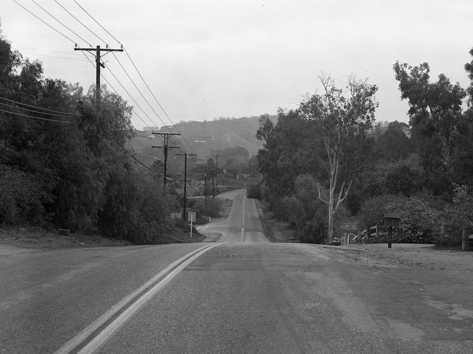
At the summit of Kellogg Hill looking west on Arroyo Avenue from its intersection with Holt Road/CHR (foreground), 1940.
Photo by the Automobile Club of Southern California, courtesy U.S.C. Digital Library.
By this time, Covina Hills Road had become well-traveled again. Post-war housing construction was booming in the area. Covina Knolls in 1947, Vallecito the following year, Covina Hills Ranchos in 1953, Castle Knolls in 1956, Covina Heights in 1966: all resulted in ever-increasing traffic.
View of the Covina Hills Ranchos and Covina Heights developments from Covina Hills Road, 1969. Personal collection.
Also in 1966, in preparation for construction of a huge new development on former Phillips Ranch lands in San Dimas, Via Verde was converted from a 2-lane country road to a divided 4-lane residential avenue. The intersection with Covina Hills Road was realigned at that point, isolating the old road's easternmost section.
In 1969, the pavement and turnouts east from Rancho El Encino Drive were widened to their present state, and in 1973, the downhill grade east from Rowland Avenue in Covina was daylighted. In 2004,17 stop signs were installed at the bottom of that grade at the intersection with Oak Canyon Road, two more at Holt, and 3-way stoplights were installed at CHR and Via Verde: the final touches which gave us the Covina Hills Road we know today.
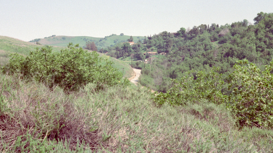
Except for some houses in the distance, this view from 1983 probably appeared little changed from a century earlier when Covina Hills Road was built.
Photo © J Scott Shannon.
After discovering all this, I think my younger self would have been disappointed to find out it wasn't ever really a stagecoach road or an indian trail, but Covina Hills Road is definitely historic in its own right, and worthy of having its story told at long last.
References:
1 Map of the McCarthy Company's subdivision of Block 1 of the Hollenbeck Tract, surveyed August, 1895.
2 Los Angeles Herald, February 7, 1894, p.6.
3 Los Angeles Herald, May 26, 1895, p.16.
4 Los Angeles Evening Express, July 17, 1895, p.4.
5 Los Angeles Herald, July 1, 1896, p.4.
6 Pomona Progress, May 9, 1923, p.6.
7 Covina Argus, January 23, 1925, p.1.
8 Pomona Bulletin, May 21, 1924, p.7.
9 Covina Argus, August 21, 1925, p.5.
10 Covina Argus, September 21, 1928, p.1.
11 Covina Argus, August 26, 1927, p.1.
12 Covina Argus, May 18, 1928, p.1.
13 Pomona Progress-Bulletin, July 1, 1932, p.13.
14 California Highways and Public Works, March, 1934, p.2.
15 Covina Argus, April 25, 1947, p.7.
16 Pomona Progress-Bulletin, September 29, 1956, p.12.
17 Letter from L.A. County Department of Public Works to Board of Supervisors, dated April 1, 2004.
8 comments:
Loved reading the history. Lived in Covina from 1960 at 12 yrs. old and rode my bike down to the creek via Covina Hills Road. I felt such freedom being able to leave my house and head that way. I have often returned to see the changes and find the part of the creek I played around.
You're lucky! My mom wouldn't let me ride my bike on Covina Hills Road at all. But I hiked to the same creek often! It really was a great place to grow up.
Great history! I moved to Via Verde in 1977 and lived there until 1993. My house backed up to the old Voorhis Boys School property that became Cal Poly Pamona before it relocated to Kellogg Ranch. Lots of history! From Mud Flats to San Dimas, from stage coach stop to I-210, 57, I-10, from Raging Waters to Bill and Ted!
I was wondering what other surface roads were used N. of the Fwy thru the hills to Pomona and not Arrow Hwy. As a kid in the 50's in Claremont a neighbor took us to the newly opened Eastland (Musta been circa 1957-58) via the freeway but we returned via surface streets but I don't recall exactly the roads she drove-Covina Hills might have been one of them-I remember it was rural and open country perhaps it was the old alignments of Via Verde and San Dimas Ave. if it existed yet, this was way before the Via Verde development.
This is amazing! Thank you for doing this !
Just catching up after a hiatus from the blog.
I remember being told not to ride my bike on CHR - after the fact. That was probably about 1970.
A while back, I saw a map from the 1920's or 30's, that showed a road (or maybe supposed to be a trail???) from the top of Via Verde (probably near what is now the intersection with San Dimas), down the south side of the hill into the Kellogg Ranch. It showed the road doing a couple of switchbacks to get down the hill. I have never seen any other map showing that road, and in driving by these days, I can see no evidence that it ever existed. Do you have any info on that??
Yes, that was the original alignment of San Dimas Avenue that connected to Holt Ave. on the south. It was opened in 1931. That stretch was obliterated during construction of the present 10-57-71 interchange c.1971. A very short section of old pavement still exists past the east end of Via Catarina, though. If there isn't a fence there, you can probably still walk down to it on foot and explore some of the old road. :-)
Post a Comment
To post a comment, you must login to this page with the Google Chrome web browser. That is the only way that works now.