Showing posts with label glendora. Show all posts

Thursday, July 23, 2026

Ira Stanton and Kin

The other day, Dave Armbruster of the Covina Valley Historical Society asked if I could help with info about this photo. The caption read, "Ira Stanton Hauling Oranges," and Dave wondered what I could find out about the gentleman.


Built in 1913, the Covina Heights Groves, Inc., packing house was located on the SPRR line just east of the northeast corner of Front and First Streets.
Ira Stanton's brother, Pliny (b.1877), was Manager,1 and also co-owner of the Stanton grove,2 so perhaps Pliny took this picture of his brother atop their wagon.


I discovered a lot about Ira and his kinfolk, but three things stood out as noteworthy:

Friday, May 8, 2026

Compromise Line Road

I hope my dozen or so regular readers will pardon me if I write about someplace other than Covina just once. ;-)

Although I was born and raised in Covina, I lived my first five years on East Foothill Boulevard in Glendora, so consequently, the history of our neighbor to the north is a natural area of interest to me.

The subject is not far out of bounds geographically, either, as both Covina and Glendora share partial origins in a historical Mexican land grant called Rancho San José Adición (aka Rancho Addition to San Jose) which just happens to be the broader topic of this article. Most of Covina's Charter Oak neighborhood lies within Adición's borders, so I'm not really straying too far afield here.

Anyway, even as a child, I had a keen interest in roads and maps which really took off after I discovered my dad's Renie Atlas around age 12 (same time as my interest in Covina history, hmm!). Probably not long after that, the name of one street in particular from my Glendora years aroused my curiosity: "Compromise Line Road." Always wondered what that meant. Somewhere in my early readings of local history, I did learn that it involved a dispute over a northern boundary of Rancho Addition to San Jose, but I never could find out much more than that.


Compromise Line Road in Glendora. Source: Renie Atlas of Los Angeles City and County, 1965 edition.


Recently I was contacted by an old classmate who asked about Compromise Line, and desiring to know more than the basics I'd heard long ago, I decided to do a deep-dive into the subject. Obvious first stop reference-wise was Donald Pflueger's Glendora (1951), but unfortunately his mention of Compromise Line Road was so nonspecific as to be no help at all. Then I searched the newspaper archive, and that was a similar dead-end.

Friday, November 7, 2025

The Squatter Era

In 1859, long before the Badilla brothers or J. S. Phillips arrived on the scene, that northern section of Covina that today lies between San Bernardino Road and Arrow Highway began being settled by enterprising American and immigrant pioneers. Featured in this article is a recently discovered telling of those settlers' story that was written in 1887, when all the events described were still in the living memory of those who witnessed them.

The land that is the subject of this newfound contemporary account was originally part of Henry ("Don Enrique") Dalton's Rancho Azusa, which the Englishman had purchased from Don Luis Arenas in 1844. At that time, Dalton's ranch encompassed most of the territory east of the San Gabriel River and south from the foothills of the San Gabriel Mountains to the old San Bernardino stage road.


Rancho Azusa de Dalton originally extended south to the northern boundary of Rancho La Puente. Alignments of selected section and quarter-section roads of today are labeled for reference.
Source: U.S. Dept. of the Interior, Bureau of Land Management, General Land Office Records. (Click on the image to view an enlargement.)

As the article below will recount, in 1858 the U. S. Government ordered a new survey of Dalton's holdings, the result of which was the invalidation of Rancho Azusa's southern and eastern boundaries. Surveyor Henry Hancock drew a new southern line for Dalton's rancho (today's Gladstone Street), thus creating 2,428.25a acres of new public land that thereupon became available for preemption, and later, homesteading.

While Pflueger (1964) gave an admirably thorough account of Covina's squatter era, this article from the January 23, 1887, edition of the Los Angeles Timesb tells the story from a unique perspective I hadn't seen in print before. So, without further ado...

Saturday, May 4, 2024

Covina's Old Neighbors

The localities described below would have been household names to Covinans during the the town's first half-century, but most are unfamiliar today.


USGS map from 1908 showing Covina and environs in the early 20th century. (Note the original alignments of roads in the area of present-day West Covina.)
Click on the image for an enlargement.

Saturday, August 14, 2021

Before Glendora Avenue

When I was a kid starting to get curious about local history, the story I heard about West Covina's Glendora Avenue was that it was called that because in olden days it went to Glendora. It did seem to point in that general direction, so I always assumed the tale was true.

But where did Glendora Avenue actually go in historical times? I didn't think to figure that out until just the other day. Turns out if I take the original 1885 survey map of Covina and precisely extend the line of today's Glendora Avenue, it very conveniently connects three important historical sites: the Julian Badilla home (1876), Eugene Griswold's 1877 Citrus Post Office and general store, and the homestead of Robert J. Pollard, who I have recently come to believe may have been the Covina area's first settler of European descent.
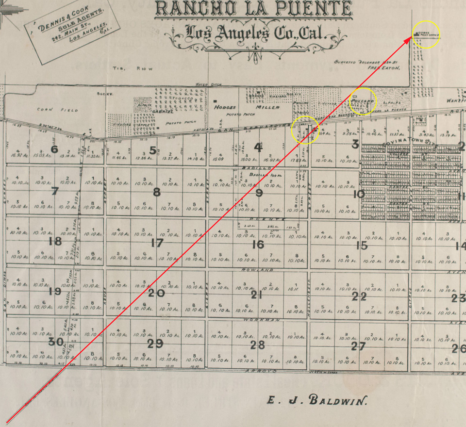

Detail of Phillips Tract map (1885) showing a proposed historical northward extension of Glendora Avenue/Puente Depot Road (red arrow).
Yellow circles indicate the Badilla, Pollard and Griswold properties respectively. Map courtesy Covina Valley Historical Society.


No maps from the 1870s show that such a road existed through the future Covina area, but it would make sense that one did, because if you were Mr. Pollard or Mr. Griswold or the Sres. Badilla, you would need a wagon road in that exact location and orientation to get you to Puente, which was not only the headquarters town of Rancho La Puente, it was also the location of the then-new Southern Pacific Railroad depot, which at the time would have been your main transportation link to the greater world beyond.

But there are maps from turn of the 20th century that do show a "Puente Depot Road" roughly tracing the path of today's Glendora Avenue. To realize my scenario, we need only imagine that the depot road went further north before the grid of streets for Covina was laid out in 1883-1884.
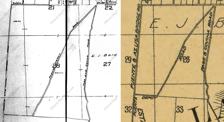

Maps from c.1900 showing "Puente Depot Road." Courtesy HistoricMapWorks.com and Library of Congress.


I don't think the diagonal Glendora Avenue we know today necessarily followed that same alignment all the way north, though. All it had to do was go as far as Citrus Avenue–a main thoroughfare named "Azusa Road #2" in the 1870s–and from there, you could have taken it up to Azusa or the foothills, where it ended at Fairmount Cemetery. In any case, Glendora wasn't founded until 1886, so the road we now call Glendora Avenue never went to such a place to begin with. The story behind the name turns out to be only the stuff of legend, after all.

One more thing: let's say the depot road did extend north to Citrus Avenue, that would finally answer a nagging question I've had for a long time, which was, why did the Badillas choose to build their HQ exactly where they did? That particular spot always seemed less than ideal to me. However, if we assume that in 1876, it was the intersection of the most crucial local roads at the time: San Bernardino Road (the most direct route to Los Angeles), the Puente Depot Road, and from there, the road north to Azusa, then the Badillas' chosen location makes perfect logistical sense.

This makes me think that the depot road existed before the Badillas arrived. So who first blazed the old wagon track to Puente? No way of knowing for certain at this point, but my guess would be R. J. Pollard, who may have been there before anybody else, but that I have yet to establish.

Much speculation here, I acknowledge, but a lot of history is informed speculation based on previously-known facts. And it's fun stuff to think about, anyway! I mean a historian's gotta have fun once in a while, right? Right!

Grateful thanks to Michael Schoenholtz and Randall Smith for research and discussion.


Thursday, August 1, 2013

Driving Around the Groves

North Grand Avenue, late 1950s. Although this particular location is in Glendora, it is very much typical of the way Covina's streets looked during the transition from citrus to suburbs. After a block of new houses, the road narrows to its original two lanes as it passes an orange grove. To the left is a row of tall Washingtonia robusta fan palms and another housing development; this one with a separate feeder road running parallel to the arterial street. (Covina had a ton of those.) And, in the midst of all those modern homes stands an old two-story grove house: a lone survivor of rural times now past.

Even into the 1970s, there were still several roads in and around Covina that suddenly narrowed to two lanes like this. The last ones that I can remember were northbound Grand Avenue between Cypress and Covina Blvd., and Vincent Ave. just south of Arrow Highway. The former was widened to four lanes around 1971, and the latter as late as 1980.

This shows the postcard location in the present day. If you jump forward a little in the street view, you can see that the old grove house at left is still standing today.